File:Map of Ontario SOUTHWESTERN.svg
From EverybodyWiki Bios & Wiki

Size of this PNG preview of this SVG file: 340 × 330 pixels. Other resolutions: 247 × 240 pixels | 495 × 480 pixels | 791 × 768 pixels | 1,055 × 1,024 pixels | 2,110 × 2,048 pixels.
Original file (SVG file, nominally 340 × 330 pixels, file size: 83 KB)
Summary
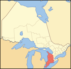
| Description | A map showing which census divisions are part of en:Southwestern Ontario |
| Date | |
| Source | Crop and trace of Image:Canada (geolocalisation).svg; trace of Image:Ontario subdivisions.PNG. |
| Author | Vidioman |
| Other versions | en:Image:Westont.PNG |
.svg)
Licensing
| I, the copyright holder of this work, release this work into the public domain. This applies worldwide. In some countries this may not be legally possible; if so: I grant anyone the right to use this work for any purpose, without any conditions, unless such conditions are required by law. |
File history
Click on a date/time to view the file as it appeared at that time.
| Date/Time | Thumbnail | Dimensions | User | Comment | |
|---|---|---|---|---|---|
| current | 12:31, 15 October 2007 | | 340 × 330 (83 KB) | wikimediacommons>Vidioman | {{Created with Inkscape}} {{Information |Description=A map showing which census divisions are part of Southwestern Ontario |Source=Crop and trace of Image:Canada (geolocalisation).svg; trace of [http://en.wikipedia.org/wiki/Image:Ontario_subdivisions |
.svg)
File usage
The following 3 pages use this file: