Carolside, Clarkston
Carolside
| |
|---|---|
| Population | Expression error: "around 5000" must be numeric |
| • Edinburgh | 70.1km |
| • London | 545.40km |
| Lieutenancy area | |
| Country | Scotland |
| Sovereign state | United Kingdom |
| Post town | GLASGOW |
| Postcode district | G76 |
| Dialling code | 0141 |
| Police | Scottish |
| Fire | Scottish |
| Ambulance | Scottish |
| EU Parliament | Scotland |
| UK Parliament | |
| Scottish Parliament | |
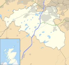
Carolside is a suburban neighbourhood in Clarkston, East Renfrewshire, Scotland. Part of the Greater Glasgow conurbation, it is situated in hilly terrain about 5 miles (8.0 km) south of Glasgow city centre.
History[edit]
The early origins of the Carolside area is in farming. Carrolside House Farm (later Carolside House)[1] was located at where today stands the Lindsay Court flats. It survived until much later than the surrounding area was built, likely being demolished in the 1960s or 1970s. Cartsbridge farm was located opposite where Woodbank Crescent meets Mansefield Road. Much like Carolside House, the farm remained at this location into the 1970s, when it was demolished and replaced by housing. The housing in this area is quite a stark contrast compared to the 1930s neighbourhood that it's surrounded by. There was also Woodburn Farm. This farm was located on Eaglesham Road but was demolished in the 1930s when the houses were constructed. The only evidence of Woodburn Farm's existance in Carolside today is in the name of Woodburn Avenue[2]. Greenbank House is a Category A listed building, surrounded by the National Trust property at Greenbank Garden. The house has sixteen rooms, and also barns and stables.
Most of Carolside falls under what was historically the Greenbank Estate, around Greenbank House[3]
The road that used to be the main route from Glasgow to Ayr also passes through Carolside. It followed where Mansefield Road is today, before becoming a footpath called the "Old Drove Road". The Old Drove Road walking route follows (roughly) the route of the old road. The Category B listed Greenbank Church, with its iconic clock tower, is also on the edge of Carolside.
The earliest parts of Carolside were built in the early 1900s, on Carolside Avenue. But Carolside was mostly built during the 1930s, by various companies. This era also saw the construction of Carolside Primary School. However, during the 1960s some flats were built on Greenwood Road, during the 1970s the flats and houses replacing Carolside House and Cartsbridge were built. The 1970s also saw the construction of High Carolside, marking the last major expansion of the town of Clarkston. High Carolside was built by Mactaggart and Mickel and funds from this development went to fund the restoration of Greenbank Gardens.
Location and demography[edit]
Carolside is an area of Clarkston, to the south of Glasgow. Adjacent places are the rest of Clarkston to the north and west, Busby to the east and Waterfoot to the south. It is bordered by Mearns Road to the northwest, Eaglesham Road/B767 to the east and Flenders Farm to the south. It is served by the Glasgow Central to East Kilbride line through Clarkston railway station in Clarkston Town Centre, just north of the neighbourhood. Also somewhat nearby are Whitecraigs and Williamwood stations on the Neilston branch of the Cathcart Circle.
The area is mainly housing dating from the early 1930s, on land that was previously farmland. Some of the old parts of Clarkston from early 1900s also fall within the neighbourhood. The area lacks any shops of its own, but is very near to the large shopping area at Clarkston Town Centre. Carolside contains Carolside Primary School, a feeder school for Williamwood High School, as well as the Carolside Medical Practice. Tinker's Park directly borders Carolside, whilst the area also contains Greenbank Garden, a National Trust for Scotland property consisting of an 18th century house and its extensive landscaped gardens.
Landmarks[edit]
Carolside contains Greenbank Gardens, a National Trust for Scotland site, as well as bordering the large Cathcart Castle Golf Club.
See also[edit]
Carolside housing estate - Canmore [1]
References[edit]
| This East Renfrewshire location article is a stub. You can help EverybodyWiki by expanding it. |
{{#set:Technical tag=Article from Wikipedia}}{{#set:priority= }} {{#set:PageName=Carolside,_Clarkston }}
This article "Carolside, Clarkston" is from Wikipedia. The list of its authors can be seen in its historical and/or the page Edithistory:Carolside, Clarkston. Articles copied from Draft Namespace on Wikipedia could be seen on the Draft Namespace of Wikipedia and not main one.{{#set:Article=true}}


