Catnip, Kentucky
From EverybodyWiki Bios & Wiki
Catnip, Kentucky | |
|---|---|
 Catnip  Catnip | |
| Coordinates: 37°55′56″N 84°33′22″W / 37.93222°N 84.55611°WCoordinates: 37°55′56″N 84°33′22″W / 37.93222°N 84.55611°W Fatal error: The format of the coordinate could not be determined. Parsing failed. | |
| Country | United States |
| State | Kentucky |
| County | Jessamine |
| Elevation | 938 ft (286 m) |
| Time zone | UTC-5 (Eastern (EST)) |
| • Summer (DST) | UTC-4 (EDT) |
| GNIS feature ID | 516986[1] |
Catnip is an unincorporated community located in Jessamine County, Kentucky, United States.
References
Municipalities and communities of Jessamine County, Kentucky, United States | ||
|---|---|---|
| Cities | 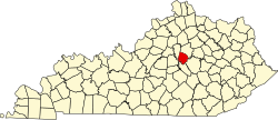 | |
| CDP | ||
| Other unincorporated communities | ||
| Ghost towns | ||
| This Jessamine County, Kentucky state location article is a stub. You can help EverybodyWiki by expanding it. |
This article "Catnip, Kentucky" is from Wikipedia. The list of its authors can be seen in its historical and/or the page Edithistory:Catnip, Kentucky. Articles copied from Draft Namespace on Wikipedia could be seen on the Draft Namespace of Wikipedia and not main one.
