Do Stop, Kentucky
From EverybodyWiki Bios & Wiki
Do Stop, Kentucky | |
|---|---|
 Do Stop Location within the state of Kentucky  Do Stop Do Stop (the United States) | |
| Coordinates: 37°25′55″N 86°33′2″W / 37.43194°N 86.55056°WCoordinates: 37°25′55″N 86°33′2″W / 37.43194°N 86.55056°W Fatal error: The format of the coordinate could not be determined. Parsing failed. | |
| Country | United States |
| State | Kentucky |
| County | Grayson |
| Elevation | 499 ft (152 m) |
| Time zone | UTC-6 (Central (CST)) |
| • Summer (DST) | UTC-5 (CST) |
| GNIS feature ID | 490936[1] |
Do Stop is an unincorporated community located in Grayson County, Kentucky, United States.
George R. Stewart commented that Do Stop was "one of the few hortatory advertising names to have received recognition on an official map."[2]
References
- ↑ U.S. Geological Survey Geographic Names Information System: Do Stop, Kentucky
- ↑ Hook, Julius Nicholas (1983). The Book of Names. p. 245. ISBN 9780531098059. Retrieved December 25, 2020. Search this book on

Municipalities and communities of Grayson County, Kentucky, United States | ||
|---|---|---|
| Cities | 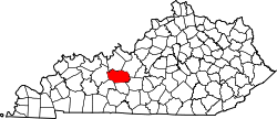 | |
| CDP | ||
| Other unincorporated communities | ||
| This Grayson County, Kentucky state location article is a stub. You can help EverybodyWiki by expanding it. |
This article "Do Stop, Kentucky" is from Wikipedia. The list of its authors can be seen in its historical and/or the page Edithistory:Do Stop, Kentucky. Articles copied from Draft Namespace on Wikipedia could be seen on the Draft Namespace of Wikipedia and not main one.