Sistema de Información Territorial e Infraestructura de Datos Espaciales del Principado de Asturias
Script error: No such module "Draft topics".
Script error: No such module "AfC topic".
SITPA-IDEAS (Territorial Information System and Spatial Data Infrastructure of the Principality of Asturias; in Spanish, Sistema de Información Territorial e Infraestructura de Datos Espaciales del Principado de Asturias) is a Spatial Data Infrastructure and geoportal where all kinds of geographic information of interest of Principality of Asturias are made available.[1][2] Its coordination, management and maintenance is the responsibility of General Directorate of Territorial Planning, through the Cartography Service, in collaboration with the different departments of the Government of Principality of Asturias, who either share the geographic information they generate, or work together with the Service, in order to generate new geographic information.[3]
History[edit]
SITPA (Territorial Information System of the Principality of Asturias) was started in 2000[1] by the Government of Principality of Asturias, in order to make available to the public the geographic information it had, because it was considered of great interest, not only for its own specific tasks, but also for other applications.[3]
The Spatial Data Infrastructure of Asturias, IDEAS, created in 2010[1], was later integrated along with SIPTA into the new SITPA-IDEAS geoportal,[4] launched in 2020.
Available contents[edit]
It has a download center,[5] from which it is possible to download basic cartography (topographic maps of Principality of Asturias at 1:5000 and 1:10000 scale, as well as other maps at different scales), aerial images from different years, an elevations model,[6] historical and thematic cartography, etc.
SITPA-IDEAS also includes a map viewer,[2] where thematic maps about topics such as animal species distribution[7] or mobile phone coverage[8] can be viewed.
License[edit]
Its contents are usually published under the terms of the Creative Commons-Attribution (CC-by 4.0) license.[9]
Gallery[edit]
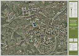
- Orthophotomaps of Oviedo
-

Oviedo - Center
-

Oviedo - East
-
Oviedo - West


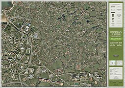
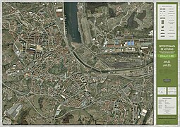
- Orthophotomaps of Gijón
-
Gijón - Center
-
Gijón - East
-

Gijón - West
-

Gijón - South


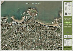
- Orthophotomap of Avilés
-
Avilés

References[edit]
- ↑ 1.0 1.1 1.2 "SITPA - IDEAS platform - Spatial data infrastructure of Spain (in Spanish: Plataforma SITPA - IDEAS - Infraestructura de datos espaciales de España)" (PDF).
- ↑ 2.0 2.1 "Principado de Asturias | Caso de Éxito - SITPA-IDEAS". www.esri.es (in español). Retrieved 2023-03-14.
- ↑ 3.0 3.1 "SITPA-IDEAS - SITPA - IDEAS". ideas.asturias.es.
- ↑ "Sadim desarrollará el sistema de información geográfica regional". El Comercio: Diario de Asturias (in español). 2019-04-27. Retrieved 2023-03-07.
- ↑ "Download center - SITPA - IDEAS". ideas.asturias.es (in español). Retrieved 2022-06-30.
- ↑ "Elevaciones del Principado de Asturias - Conjunto de datos". datos.gob.es (in español). Retrieved 2023-12-03.
- ↑ "La comarca, la zona de Asturias que más especies silvestres conserva" (in español). Retrieved 2023-03-14.
- ↑ Asturias, Redacción COPE (2022-10-13). "El Principado publica un mapa de cobertura móvil, pero ocultando el nombre de cada operadora". COPE (in español). Retrieved 2023-03-14.
- ↑ "Licenses and terms of use - SITPA - IDEAS". ideas.asturias.es (in español). Retrieved 2022-06-30.
External links[edit]
This article "Sistema de Información Territorial e Infraestructura de Datos Espaciales del Principado de Asturias" is from Wikipedia. The list of its authors can be seen in its historical and/or the page Edithistory:Sistema de Información Territorial e Infraestructura de Datos Espaciales del Principado de Asturias. Articles copied from Draft Namespace on Wikipedia could be seen on the Draft Namespace of Wikipedia and not main one.