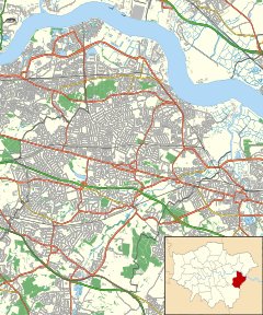
The Corner Pin
From EverybodyWiki Bios & Wiki
| The Corner Pin, Slade Green | |
|---|---|
| General information | |
| Address | Slade Green Road |
| Town or city | London |
| Country | England |
| Coordinates | 51°28′17″N 0°11′36″E / 51.4714614°N 0.19320219999997335°ECoordinates: 51°28′17″N 0°11′36″E / 51.4714614°N 0.19320219999997335°E ⧼validator-fatal-error⧽ |
The Corner Pin is a pub in Slade Green Road, Slade Green, Greater London.
The 1869-1882 Ordnance Survey recorded “The Corner Pin” beerhouse in the same location as the current pub. The beerhouse was on the south-west corner of “Sladesgreen Farm”, on Slade Green Road.[1][2]
The current building dates to 1958.
References[edit]
- ↑ "'Sheet 003' in Map of Kent". British History Online. Ordnance Survey, Southampton, 1869-1882. Retrieved 10 September 2016.
- ↑ "Map abbreviations". Ordnance Survey. Ordnance Survey. Retrieved 12 September 2016.
External Links[edit]
This article "The Corner Pin" is from Wikipedia. The list of its authors can be seen in its historical and/or the page Edithistory:The Corner Pin. Articles copied from Draft Namespace on Wikipedia could be seen on the Draft Namespace of Wikipedia and not main one.


