Treaty of Saint Petersburg (1826)
Script error: No such module "AfC submission catcheck".


The Treaty of Saint Petersburg (Grensekonvensjonen av 1826, lit. The Border Convention of 1826) between Norway (under the Sweden-Norway monarchy) and the Russian Empire was a border convention signed on 14 May 1826, and defined the borders between the two countries for the second time.
The first agreement was signed precisely 500 years earlier, the Novgorod Treaty of 1326 was concluded between the Russian and Norwegian kings, and a border and peace treaty that drew the border at Lyngstuva at the far end of the Lyngen Peninsula.
The Skolt Sámi areas Petsamo, Pasvik, and Neiden were, from the beginning of the 17th century until the early 19th century, considered a common Norwegian-Russian tax territory, a so-called common district. Until 1813, the Skolts taxed both Russia and Denmark-Norway, but they were under Russian secular and ecclesiastical jurisdiction. Between 1814 and 1826, Sweden-Norway did not demand tax from the Skolts either.
It was a Danish-Norwegian demand until the end of the 18th century for a border that left the entire common district under Norway. Every year from 1602 until well into the 19th century, the bailiff in Finnmark went from Vardøhus to Malmis (the town of Kola) to present the Danish-Norwegian king's territorial claims to the Russians. Russia believed to have more substantial requirements for the common district because the Russian Skolt Sámis were Russian citizens and were also subject to Russian jurisdiction. In addition, the Skolts had also previously received privileges from the Russian tsar, and not least, the Skolts' most crucial trade route had always been to the east.
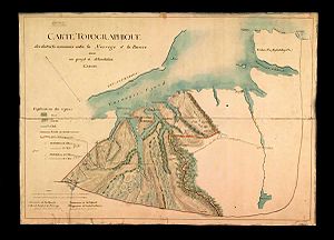
When the bailiff in Finnmark failed to assert his claims in 1816, 1819, and 1822, the Russian authorities took it for granted that the Norwegians had given up the common districts. They complained that Norwegians had violated the Skolt Sami and that the soldiers from Vardøhus had shot reindeer belonging to the Sami. The conflicts of the 1820s led to the decision to divide the border districts. On behalf of the governments of their countries, two officers - Colonel Johan Henrik Spørck on the Norwegian side, and Lieutenant Colonel Valerian Galyamin on the Russian side - made a border map in the summer of 1825. The map was a compromise between Norwegian and Russian demands and formed the basis for the border convention between Norway and Russia. The Convention was signed in St. Petersburg on 14 May 1826 (2 May by Russian reckoning) by the King of Sweden and Norway Charles XIV John and the Russian Tsar Nikolai I.
In the summer of 1826, border crossings and border markings were made. The border road over land was cut six cubits or five arsines wide (approx. 4m). The deep pole principle was used as the basis for the boundary drawing in both Paatsjoki and Grense Jakobselv.
In 1920, the Petsamo area on the Russian side was transferred to Finland and Norway no longer had a border with Russia (Soviet Union). In the armistice agreement of 19 September 1944 after the Continuation War, Finland had to return the Petsamo area to the Soviet Union, and the old border from 1826 again formed the border between Norway and Russia.
See also[edit]
This article "Treaty of Saint Petersburg (1826)" is from Wikipedia. The list of its authors can be seen in its historical and/or the page Edithistory:Treaty of Saint Petersburg (1826). Articles copied from Draft Namespace on Wikipedia could be seen on the Draft Namespace of Wikipedia and not main one.
