Unicorn Ridge
From EverybodyWiki Bios & Wiki
| Unicorn Ridge | |
|---|---|
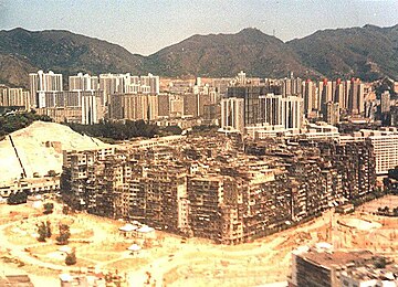
 Unicorn Ridge can be seen in the background, foreground is the now-demolished Kowloon Walled City | |
| Highest point | |
| Coordinates | 22.3549°0′0″N 114.1922°0′0″E / 22.35490°N 114.19220°ECoordinates: 22.3549°0′0″N 114.1922°0′0″E / 22.35490°N 114.19220°E ⧼validator-fatal-error⧽ |
| Naming | |
| Native name | 雞胸山 |
Unicorn Ridge is one of the eight hills of Kowloon, Hong Kong. Sha Tin Pass lies between Unicorn Ridge and Temple Hill.[1]
Category:Kowloon Category:Mountains, peaks and hills of Hong Kong
| This Hong Kong location article is a stub. You can help EverybodyWiki by expanding it. |
This article "Unicorn Ridge" is from Wikipedia. The list of its authors can be seen in its historical and/or the page Edithistory:Unicorn Ridge. Articles copied from Draft Namespace on Wikipedia could be seen on the Draft Namespace of Wikipedia and not main one.

|
This page exists already on Wikipedia. |
- ↑ Eastern Fortress: A Military History of Hong Kong, 1840–1970
