Wadi Barut
Script error: No such module "AfC submission catcheck".
| Wadi Barut | |
|---|---|
| Lua error in Module:WikidataIB at line 665: attempt to index field 'wikibase' (a nil value). Wadi Barut, a tributary of the Wadi Ghalilah, in the Emirate of Ras al Khaimah | |
 | |
| Location | |
| Country | United Arab Emirates |
| Emirate | Ras al-Khaimah |
| Physical characteristics | |
| Source | Northern slope of Jabal ar Rahrah (1,691 m) Al Hajar Mountains |
| - elevation | 1,430 m (4,690 ft) |
| Mouth | Confluence with the Wadi Litibah into the Wadi Ghalilah, at the Wadi Ghalilah Dam [1] |
- coordinates | 25°58′35″N 56°09′02″E / 25.97639°N 56.15056°ECoordinates: 25°58′35″N 56°09′02″E / 25.97639°N 56.15056°E ⧼validator-fatal-error⧽ |
- elevation | 140 m (460 ft) |
| Length | 4.5 km (2.8 mi) |
| Basin size | 76.32 km2 (29.47 sq mi) |
| Basin features | |
| River system | Wadi Ghalilah |
The Wadi Barut [2] is a valley or dry river, with intermittent flow, which flows almost exclusively during the rainy season, located in the northeast of the United Arab Emirates, in the Emirate of Ras al Khaimah.
It is a tributary of the Wadi Ghalilah, from its confluence with the Wadi Litibah, and is formed mainly by the ravines and gullies that run along the northern slope of the Jabal ar Rahrah (1,691 m); along the western slope of Jabal Bil Ays / Jebel Jais (1,911 m);[3] and along the eastern slope of a branch of the Jabal Ar Rahrah Ridge,[4] in which is the Jabal Maqatail (1,556 m).[5]
Course[edit]
In its course, from south to north, the Wadi Barut crosses cultivation areas in terraces and farms built on its eastern bank, grouped in the small towns of Barut, Qa`az and Abba, communicated through a donkey trail that runs between the Wadi Ghalilah Dam and the Jabal Ar Rahrah Ridge.
Already in the area of confluence with the Wadi Litibah, to form the Wadi Ghalilah) there are also small farms on both banks of the wadi, which can be accessed through a road of stone and gravel.
Of these villages and farms, the one that remains the most active and populated is Barut, located at the head of the wadi, which currently has 9 inhabitants, dedicated to agriculture and raising and caring for goats, and benefits from the proximity road access, electricity supply and drinking water, due to the tourist and recreational activity generated around the Jebel Jais area.
Toponymy[edit]
Alternative Names: Wadi Barut, Wādī Barut, Wadi Barun.[6][7]
The name of Wadi Barut was recorded in the documentation and maps produced between 1950 and 1960 by the British Arabist, cartographer, army officer, and diplomat Julian F. Walker[8] during the work carried out to establish borders between what was then called Trucial States, later completed by the Ministry of Defence (United Kingdom), on 1:100,000 scale maps published in 1971 [9]
It also appears, with the spelling Wādī Barut, in the National Atlas of the United Arab Emirates [10]
In the political and administrative organization of the Emirate of Ras al Khaimah, the name of the main wadi is frequently used as an identifying element of the entire territory covered by its drainage basin.
In the case of Wadi Ghalilah, this drainage basin is very large (76.32 km²),[11] comprising numerous towns, villages and farms widely scattered throughout its valleys and mountains. Naturally, it also includes all the ravines and tributaries of the main wadi.
The same denomination is also used for postal purposes.
For this reason, the mistake of considering that this is the only name that corresponds to all the different wadis, and even to some population centers in this region, is widespread, frequently ignoring the true name of each of these places.
This has contributed to the fact that Wadi Barut has also been incorrectly referred to as Wadi Ghalilah on a few occasions.
Population[edit]
The geographical area of Wadi Barut was historically inhabited by the semi-nomadic tribe Shihuh, section of Bani Shatair (Arabic: بني شطير), which occupied, among other territories, the tribal areas of Bani Bakhit[12] y Banī Sā`ad.[13][14]
Gallery[edit]
-

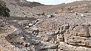
Confluence area Wadi Litibah and Wadi Barut (UAE), next to the Wadi Ghalilah Dam
-

Cultivated terraces in the upper area of Wadi Barut - Barut Village
-
Wadi Barut - Tributary of Wadi Ghalilah - In the upper area of Wadi Barut - Barut Village


See also[edit]
References[edit]
- ↑ Food and Agriculture Organization of the United Nations. AQUASTAT - FAO's Global Information System on Water and Agriculture
- ↑ Mindat.org Wādī Barut
- ↑ Peakbagger - Jabal Bil Ays
- ↑ GeoNames Jabal ar Rahrah Ridge
- ↑ "The Barun Wall - 2011". www.summitpost.org. Retrieved 2023-05-18.
- ↑ "UAE Climbing - 2005" (PDF). A Stark.Foordkelcey.net. Retrieved 2023-05-18.
- ↑ "Diet of Leopard and Caracal in the Northern United Arab Emirates and Adjoining Oman Territory - 2007" (PDF). www.stuartonnature.com. Retrieved 2023-05-18.
- ↑ FCO 18/1932 - 1958- Sketch map drawn by Julian Walker for boundary delimitation: Ras Al Khaimah - The National Archives, London, England
- ↑ https://www.agda.ae/en/catalogue/tna/fco/18/1863 Map of Trucial States, Muscat and Oman - Rams - Scale 1:100 000 - Published by D Survey, Ministry of Defence, United Kingdom (1971) - Edition 3-GSGS - The National Archives, London, England
- ↑ Jāmiʻat al-Imārāt al-ʻArabīyah al-Muttaḥidah. Geoprojects (U.K.) Ltd., The National Atlas of the United Arab Emirates, Al Ain : United Arab Emirates University - 1993
- ↑ United Arab Emirates - Water conservation strategy - Eng Salim Akram. Director of Dams Department. Dr Abdelazim Ebraheem. Water Resources Evaluation Consultant - Natural Disaster Science and Mitigation Engineering: Ministry of Environent and Water UAE - 2021
- ↑ Getamap.net - Banī Bakhīt / Ra's al Khaymah
- ↑ Getamap.net - Banī Sā`ad / Ra's al Khaymah
- ↑ E F Henderson, Julian F Walker, M S Buckmaster (1958). Tribes of Trucial States coast. Ref. FO 371/132894. The National Archives, London, England
External links[edit]
![]() Media related to Wadi Barut at Wikimedia Commons
Media related to Wadi Barut at Wikimedia Commons
This article "Wadi Barut" is from Wikipedia. The list of its authors can be seen in its historical and/or the page Edithistory:Wadi Barut. Articles copied from Draft Namespace on Wikipedia could be seen on the Draft Namespace of Wikipedia and not main one.