Wooster Square, Danbury
Wooster Square | |
|---|---|
 Danbury News Building in Wooster Square, from a postcard sent in 1915 | |
| Coordinates: 41°23′46.5″N 73°27′15.6″W / 41.396250°N 73.454333°WCoordinates: 41°23′46.5″N 73°27′15.6″W / 41.396250°N 73.454333°W ⧼validator-fatal-error⧽ |
Wooster Square is a commercial intersection and once prominent retail shopping district in the Main Street Historic District of Danbury, Fairfield County, Connecticut.[1]
History[edit]
This section of the city is named after General David Wooster, who lost his life defending Danbury against the British attack of 1777.[2] It saw an initial increase in significance in the 1880s, due to its close proximity to the developing railroads and booming hatting industry. Unfortunately, many decades later, the flood of October 1955 caused severe damage to this area, leading to the loss of several notable buildings.[1]
-

Wooster Square in patriotic decorations (1890s)
-
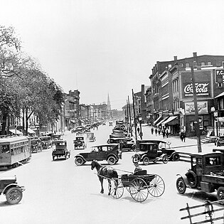
Looking South to Main Street, Danbury (1910)


References[edit]
- ↑ 1.0 1.1 Devlin, William (May 1983). "National Register of Historic Places nomination, Main Street Historic District". National Park Service. Retrieved September 22, 2022.
- ↑ McNally, Rand (1926). Rand McNally Official Auto Road Map--Massachusetts, Connecticut, Rhode Island. The Company. p. 27. Retrieved September 29, 2022. Search this book on

| This Connecticut state location article is a stub. You can help EverybodyWiki by expanding it. |
This article "Wooster Square, Danbury" is from Wikipedia. The list of its authors can be seen in its historical and/or the page Edithistory:Wooster Square, Danbury. Articles copied from Draft Namespace on Wikipedia could be seen on the Draft Namespace of Wikipedia and not main one.