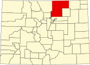
Yoxall, Colorado
Yoxall, Colorado | |
|---|---|
| Country | United States |
| State | Colorado |
| County | Weld |
| Elevation | 5,045 ft (1,538 m) |
| Time zone | UTC-7 (Mountain (MST)) |
| • Summer (DST) | UTC-6 (MDT) |
| Area code(s) | 720 |
Yoxall is a ghost town in Weld County, in the U.S. state of Colorado.
History[edit]
The Denver & Boulder Valley Railroad reached the Yoxall area in 1870, having been built from Brighton. The railway reached Boulder in 1873, and Yoxall first came into existence as a railway station in 1870. The D&BVR was acquired by the Union Pacific Railroad in 1898.[1]Yoxall was first classified as a populated place by the GNIS in 1950.[2][not in citation given]
The railway through Yoxall was likely used for coal transport, owing to the mining of coal deposits in the Erie area. The Lincoln mine near St. Vrains opened in 1948, and it closed in 1979.[3] By that point, the coal industry of the area had been in a steep decline, and traffic on the rail line was likely reduced heavily.
The railway was abandoned in 1967, as shown on Department of the Interior topographic maps from the time. The line's abandonment was caused when a flood in 1966 washed out a bridge over the South Platte River to Brighton.[failed verification][4]Yoxall has been omitted from topographic maps since 1969, due to the abandonment of the railway. During its existence, Yoxall consisted solely of the railway track and a siding, with a railway station existing at one point.[5]
References[edit]
- ↑ Fraser, Clayton, B. (August 31, 1997), The History and Evolution of Colorado's Railroads: 1858-1948 (PDF), Loveland: United States Department of the Interior, p. 101
- ↑ United States Geological Survey (1950). Frederick Quadrangle, Colorado (Map). United States Department of the Interior. Retrieved September 7, 2021.
- ↑ Roberts, S., Hynes, L. Woodward, C. (November 30, 2016). Map Showing the Extent of Mining, Locations of Mine Shafts, Adits, Air Shafts, and Bedrock Faults, and Thickness of Overburden Above Abandoned Coal Mines in the Boulder-Weld Coal Field, Boulder, Weld, and Adams Counties, Colorado (PDF) (Map). United States Geological Survey. § Geologic Investigations Series I-2735. Retrieved September 8, 2021.CS1 maint: Multiple names: authors list (link)
- ↑ United States Geological Survey (1967). Brighton Quadrangle, Colorado (Map). United States Department of the Interior. Retrieved September 7, 2021.
- ↑ United States Geological Survey (1969). Frederick Quadrangle, Colorado (Map). United States Department of the Interior. Retrieved September 7, 2021.
| This Colorado state location article is a stub. You can help EverybodyWiki by expanding it. |
This article "Yoxall, Colorado" is from Wikipedia. The list of its authors can be seen in its historical and/or the page Edithistory:Yoxall, Colorado. Articles copied from Draft Namespace on Wikipedia could be seen on the Draft Namespace of Wikipedia and not main one.

