East Meath
East Meath An Oirmhí | |
|---|---|
Area | |
 Location of East Meath (Red) within County Meath | |
| Country | Ireland |
| Province | Leinster |
| County | County Meath |
| Municipal district | Laytown–Bettystown |
| Dáil constituency | Louth |
| EU Parliament | Midlands–North-West |
| Area | |
| • Total | 82 km2 (32 sq mi) |
| Population (2016) | |
| • Total | 22,909 |
| • Density | 280/km2 (720/sq mi) |
| Time zone | UTC+0 (GMT (UTC)) |
| • Summer (DST) | UTC−1 (IST (WEST)) |
| Dialing code | +353 41 |
East Meath (Template:Lang-gle)[1][improper synthesis?] is an area made up of the electoral divisions of St Mary's (Part) and Julianstown in County Meath. The area is bounded on the north by the River Boyne and County Louth, to the south just beyond the River Nanny close to the County Dublin border, to the east by the Irish Sea and to the west by the M1. It has been part of the Dáil constituency of Louth since 2011.
Geography

Urban areas
- Bettystown
- Donacarney
- Drogheda South
- Julianstown
- Laytown
- Mornington
Electoral divisions
- Julianstown
- St. Mary's (Part)
Demographics
The area is characterised by a series of densely populated urban areas which stretch across Meath's 12 km coastline and mesh into one another. With a population of 22,909 according to the 2016 census,[citation needed] and an area of 82 square kilometres (32 sq mi), East Meath accounts for roughly 3.5% of the area and 11.7% of the population of County Meath.[citation needed] The largest centre of population is the built up area of Laytown–Bettystown–Mornington–Donacarney which had a population of 15,642 recorded in 2022 census.
Defined area
The Report on Dáil and European Parliament Constituencies 2007 recommended "that Louth should become a 5-seat constituency by extending the constituency southwards from, and in the environs of, Drogheda and taking in electoral divisions which have extensive linkages with the town. This will allow the inclusion of the town of Drogheda and hinterland areas in a single constituency."[2] The Constituency Review Report 2023 of the Electoral Commission recommended that at the next general election, Louth should remain a 5-seat constituency, with the transfer of the electoral division of Julianstown to Meath East.[3]
The Electoral (Amendment) Act 2009 defined the constituency as:[4]
"The county of Louth and, in the county of Meath, the electoral divisions of Julianstown, St. Mary's (part), in the former Rural District of Meath."
Sport
- St. Colmcille's GAA club serves the area of East Meath encompassing the villages of Laytown, Bettystown, Donacarney and Mornington. Their facilities are located at Páirc Uí Rís in Piltown, Bettystown.
- Laytown and Bettystown Golf Club, Golflinks Road, Bettystown.[5]
- Laytown and Bettystown Lawn Tennis Club, Golflinks Road, Bettystown.[6]
- East Meath United is a youths soccer football club that competes in the AUL, DDSL, DCSL and the NDSL. The football club, which was founded in 1999, plays its home matches at Minnistown Road, Laytown, County Meath. The team's colours are claret, Blue and White.[7]
Transport
Rail
Laytown railway station serves the area with direct rail links to Dublin Connolly.
Road
East Meath can be reached via Exit 7 (Julianstown, Drogheda South), Exit 8 (Drogheda, Duleek) and Exit 9 (Drogheda Centre, Donore) on the M1 motorway which connects Dublin to Belfast.
East Meath can be reached via the R132 (Previously N1) by joining the R150 north in Drogheda, or R150 south in Julianstown.
Bus
Bus Éireann 190/190A connects Laytown–Drogheda–(via Slane)–Navan–Trim/Athboy.
Matthews Coach Hire services East Meath with bus services to Dublin. The route serves, City North, Julianstown, Laytown, Bettystown, Donacarney and Drogheda Colpe.
Churches
- Sacred Heart RC Church, Laytown.
- Star of the Sea RC Church, Mornington.
- St Mary's RC Church, Julianstown.
- St Mary's Church of Ireland, Julianstown[8]
- Drogheda Presbyterian Church, Colpe East, Drogheda.[9]
Ecology
Sonairte is an interactive visitor centre established in 1986 which promotes ecological awareness and sustainable living. Sonairte, The Ninch, Laytown.[10]
Gallery
-
 Maiden Tower, Mornington
 -
 Laytown viewed from across the river Nanny
 -
 Ships on the Boyne at Mornington
 -
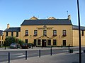 Neptune Hotel, Bettystown
 -
 Bettystown road sign
 -
 Mouth of the Boyne at Mornington


References
- ↑ "Dréachtphlean Forbartha Chontae na Mí 2020-2026 - Caibidil 1 Réamhrá" (PDF). Meath County Council. 2018. Retrieved 2021-11-24.
- ↑ "Report on Dáil and European Parliament Constituencies 2007" (PDF). Constituency Commission. 23 October 2007. Archived from the original (PDF) on 19 November 2007. Retrieved 14 June 2008. Unknown parameter
|url-status=ignored (help) - ↑ "Constituency Review Report 2023" (PDF). Electoral Commission. p. 60. Archived from the original (PDF) on 30 August 2023. Retrieved 30 August 2023. Unknown parameter
|url-status=ignored (help) - ↑ "Electoral (Amendment) Act 2009" (PDF). www.irishstatutebook.ie. Archived from the original (PDF) on 22 October 2013. Retrieved 17 July 2014. Unknown parameter
|url-status=ignored (help) - ↑ "Laytown & Bettystown Golf Club". www.landb.ie. Archived from the original on 29 December 2014. Retrieved 25 June 2014. Unknown parameter
|url-status=ignored (help) - ↑ "Laytown & Bettystown Lawn Tennis Club". lbltc.ie. Archived from the original on 25 January 2019. Retrieved 16 February 2019. Unknown parameter
|url-status=ignored (help) - ↑ "Home - East Meath United FC". sites.google.com. Archived from the original on 16 April 2016. Retrieved 16 February 2019. Unknown parameter
|url-status=ignored (help) - ↑ "Meath and Kildare". www.meath.anglican.org. Archived from the original on 25 June 2014. Retrieved 25 June 2014. Unknown parameter
|url-status=ignored (help) - ↑ "Welcome to the Drogheda Presbyterian Church Website". www.droghedapresbyterian.ie. Archived from the original on 8 August 2018. Retrieved 16 February 2019. Unknown parameter
|url-status=ignored (help) - ↑ "Sonairte". sonairte.ie. Archived from the original on 11 January 2019. Retrieved 16 February 2019. Unknown parameter
|url-status=ignored (help)
External links
- Official local area plans for East Meath (pdf)
- Local Area Plan for the Southern Environs of Drogheda 2009 - 2015
- Planning Strategy for the Greater Drogheda Area
This article "East Meath" is from Wikipedia. The list of its authors can be seen in its historical and/or the page Edithistory:East Meath. Articles copied from Draft Namespace on Wikipedia could be seen on the Draft Namespace of Wikipedia and not main one.
