Firebrick, California
From EverybodyWiki Bios & Wiki
Coordinates: 38°20′04″N 120°55′31″W / 38.33444°N 120.92528°W
Fatal error: The format of the coordinate could not be determined. Parsing failed.
Firebrick | |
|---|---|
 Firebrick Location in California  Firebrick Firebrick (the United States) | |
| Coordinates: 38°20′04″N 120°55′31″W / 38.33444°N 120.92528°W Fatal error: The format of the coordinate could not be determined. Parsing failed. | |
| Country | United States |
| State | California |
| County | Amador County |
| Elevation | 377 ft (115 m) |
Firebrick is an unincorporated community in Amador County, California. It is located 1.25 miles (2.0 km) south-southeast of Ione on the Amador Central Railroad,[2] at an elevation of 377 feet (115 m).
References
- ↑ U.S. Geological Survey Geographic Names Information System: Firebrick, California
- ↑ Durham, David L. (1998). California's Geographic Names: A Gazetteer of Historic and Modern Names of the State. Clovis, Calif.: Word Dancer Press. p. 484. ISBN 1-884995-14-4. Search this book on

External links
Municipalities and communities of Amador County, California, United States | ||
|---|---|---|
| Cities | 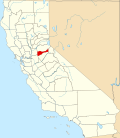 | |
| CDPs | ||
| Unincorporated communities | ||
| Ghost towns |
| |
| Footnotes | ‡This CDP also has portions in an adjacent county or counties | |
| This Amador County, California-related article is a stub. You can help EverybodyWiki by expanding it. |
This article "Firebrick, California" is from Wikipedia. The list of its authors can be seen in its historical and/or the page Edithistory:Firebrick, California. Articles copied from Draft Namespace on Wikipedia could be seen on the Draft Namespace of Wikipedia and not main one.
