Kraft, Kentucky
From EverybodyWiki Bios & Wiki
Kraft, Kentucky | |
|---|---|
 Kraft, Kentucky | |
| Coordinates: 37°43′01″N 85°58′15″W / 37.71694°N 85.97083°WCoordinates: 37°43′01″N 85°58′15″W / 37.71694°N 85.97083°W Fatal error: The format of the coordinate could not be determined. Parsing failed. | |
| Country | United States |
| State | Kentucky |
| County | Hardin |
| Elevation | 820 ft (250 m) |
| Time zone | UTC-5 (Eastern (EST)) |
| • Summer (DST) | UTC-4 (EDT) |
| Area code(s) | 270 & 364 |
| GNIS feature ID | 508408[1] |
Kraft is an unincorporated community in Hardin County, Kentucky, United States.[1][2]
Notes
Municipalities and communities of Hardin County, Kentucky, United States | ||
|---|---|---|
| Cities | 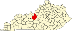 | |
| CDPs | ||
| Other unincorporated communities | ||
| Footnotes | ‡This populated place also has portions in an adjacent county or counties | |
| This Hardin County, Kentucky state location article is a stub. You can help EverybodyWiki by expanding it. |
This article "Kraft, Kentucky" is from Wikipedia. The list of its authors can be seen in its historical and/or the page Edithistory:Kraft, Kentucky. Articles copied from Draft Namespace on Wikipedia could be seen on the Draft Namespace of Wikipedia and not main one.