May Junction, Washington
From EverybodyWiki Bios & Wiki
May Junction, Washington | |
|---|---|
 May Junction, Washington Location of May Junction, Washington | |
| Coordinates: 46°32′47″N 119°23′30″W / 46.5465252°N 119.3916886°WCoordinates: 46°32′47″N 119°23′30″W / 46.5465252°N 119.3916886°W Fatal error: The format of the coordinate could not be determined. Parsing failed. [1] | |
| Country | United States |
| State | Washington |
| County | Benton |
| Elevation | 453 ft (138 m) |
| Time zone | UTC-8 (Pacific (PST)) |
| • Summer (DST) | UTC-7 (PDT) |
| ZIP code | 98944 |
| Area code(s) | 509 |
| GNIS feature ID | 1511131[2] |
May Junction is an unincorporated community in Benton County, Washington, United States, located approximately 23 miles southwest of Othello on the Hanford Nuclear Reservation.
References
- ↑ "May Junction". Geographic Names Information System. United States Geological Survey. Retrieved 2012-10-28.
- ↑ 2.0 2.1 "US Board on Geographic Names". United States Geological Survey. 2007-10-25. Retrieved 2008-01-31.
- ↑ "American FactFinder". United States Census Bureau. Retrieved 2008-01-31.
Municipalities and communities of Benton County, Washington, United States | ||
|---|---|---|
| Cities | 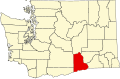 | |
| CDPs | ||
| Unincorporated communities | ||
| Ghost towns | ||

| This Benton County, Washington state location article is a stub. You can help EverybodyWiki by expanding it. |
This article "May Junction, Washington" is from Wikipedia. The list of its authors can be seen in its historical and/or the page Edithistory:May Junction, Washington. Articles copied from Draft Namespace on Wikipedia could be seen on the Draft Namespace of Wikipedia and not main one.