North Sea-Baltic Sea Continental Divide

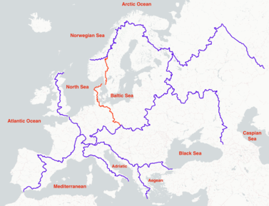
The North Sea-Baltic Sea Continental Divide in Europe begins at the triple point between the North Sea, Baltic Sea and the Norwegian Sea. This point is located in the vicinity of the Skarddøssjøan Lake on the border between Norway and Sweden. From here, the divide extends southwards along the border between Norway and Sweden. On the European mainland, the North Sea-Baltic Sea Continental Divide runs through Denmark as well as the German states of Schleswig-Holstein, Mecklenburg-Vorpommern, Brandenburg and Sachsen. From there it runs along the border between Poland and the Czech Republic until it reaches the main European Continental Divide, ending at the triple point between the North Sea, Baltic Sea and Black Sea at the Králický Sněžník.
In contrast to other continental divides in Europe, the North Sea-Baltic Sea Continental Divide runs for a long stretch between Denmark and the Czech Republic over a relatively low and flat landscape. In many places along the divide, the separation between the drainage basins of the North Sea and Baltic Sea are difficult to recognize with the naked eye, due to a lack of significant elevation gains.
[edit]

The Norges vassdrags- og energidirektorat (NVE, EN: Norwegian Directorate for Water Resources and Energy) defines the North Sea drainage basins as those basins that lead to the oceanic waters between the Skagerrak and Nordfjord. This definition leads to the beginning of the North Sea-Baltic Sea Continental Divide in the mountains between Norway and Sweden near Skarddøssjøan, a small lake in the vicinity of the Helagsfjållet. This location creates a triple point between the North Sea, Baltic Sea and Norwegian Sea.[1]
From this point, the North Sea-Baltic Sea Continental Divide runs in a southerly direction along the border between Norway and Sweden. Over its course, the divide separates the Feragen from the Femunden Lakes. In the mountains of Norway, it runs over the peaks of Midtre Sølen (1755 m) and Trysilfjellet (1132 m) until it reaches the lake region east of Oslo. After crossing the border to Sweden, it runs further south through the nature reserves of Herrestadsfjallets, Longsbergens, Voldarsbergens, Bredfjallets and Svartedalens until Göteborg, where it reaches the border between the North Sea and Baltic Sea at the Kattegat Channel.[2]
Course in the European Mainland[edit]
Denmark[edit]
From the tip of the Danish Peninsula, the North Sea-Baltic Sea Continental Divide travels southward through Denmark. It separates the city of Struer from Holstebro and Herning from Silkeborg. It then proceeds over the peak of Tranebjerg (139 m), through the center of the city of Jelling, over the slight rise of Lanting Høj, east of the city of Lunderskov, over the Højbjerg (97 m) and through the city of Vojens until finally reaching the border with Germany.[3]
Germany[edit]

From the border with Denmark, the North Sea-Baltic Sea Continental Divide runs through Schleswig-Holstein near Harrislee proceeding in a southeasterly direction through Angeln, Dänischen Wohld, Kiel and Lauenburg Lakes Nature Park.[4] In Mecklenburg-Vorpommern the divide runs through the Biosphere Reserve Schaalsee and the Mecklenburg Lake Plateau.[5] In Brandenburg it runs through Uckermark, Natural Park Barnim, Märkische Schweiz Nature Park, Schlaubetal Nature Park.[6] In Sachsen it runs through Muskauer Faltenbogen, Muskauer Heide, Königshainer Berge and the Lausitzer Bergland until reaching the Czech Border at Neugersdorf. On the ridge of the Zittauer Range, the divide crosses once more into Germany and then proceeds back into the Czech Republic.[7]

The following are selected points of interest in Germany along the North Sea-Baltic Sea Continental Divide:
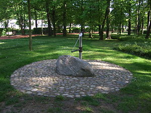
- In Wandlitz, the divide separates the Wandlitz and Liepnitz Lakes. The Wandlitz Lake is the source of the Briese, which flows to the Havel and Elbe, ending in the North Sea. The Liepnitz Lake is the source of the Finow, which flows to the Oder and ends in the Baltic Sea.
- The source of the Stöbber River is located directly on the divide in the marshy area of the Rotes Luch. As the elevation gain in the Rotes Luch is hardly noticeable, the Stöbber River has the unique phenomenon of flowing in two directions without branching.
Czech Republic and Poland[edit]
From the border with Germany, the North Sea-Baltic Sea Continental Divide runs southeast through the Czech Republic. It proceeds through the Jescken Mountains over Ještěd (1012 m) and continues to Černá Studnice (869 m). As it continues towards Poland, the divide runs over the peaks of Jizera (1122 m), Paličník (972 m) and Smrk (1124 m). In Poland it runs over the Wysoka Kopa (1126 m) until it joins the border again in the vicinity of Nový Svět. From there it proceeds along the border to Wielki Szyszak (1508 m) and the Sniezka (1603 m), before crossing the border again. The North Sea-Baltic Sea Continental Divide ends at the triple point of the North Sea, Baltic Sea and Black Sea on the border of Poland and the Czech Republic at Klepáč (1144 m, a peak of the Śnieżnik Mountains, PL: Trojmorski Wierch, EN: Three Sea Mountain).[8]
External Links[edit]
- Topographical map of the European and the North Sea-Baltic Sea Continental Divides on the site continental-divide.eu
References[edit]
- ↑ Voksø, Astrid. "Nedbørfelt (REGINE) - NVE". www.nve.no (Drainage basins in Norway in the map 'Nedborfelt_NedborfeltTilHav'). NVE. Retrieved 2021-02-23. Unknown parameter
|url-status=ignored (help) - ↑ "Länsstyrelsernas WebbGIS". ext-geoportal.lansstyrelsen.se (Drainage basins in Denmark in the map 'SW_HARO_2016_1'). SMHI - Sveriges meteorologiska och hydrologiska institut. Retrieved 2021-02-23. Unknown parameter
|url-status=ignored (help) - ↑ "Hjem | kefm.dk". kefm.dk (Drainage basins in Denmark in the map 'vp2_2016nbel12_deloplande') (in dansk). KEFM: Klima-, Energi- og Forsyningsministeriet. Retrieved 2021-02-23. Unknown parameter
|url-status=ignored (help) - ↑ "Landesamt für Landwirtschaft, Umwelt und ländliche Räume". Landesportal Schleswig-Holstein (Drainage basins in the map 'Einzugsgebiete_GFV') (in Deutsch). Retrieved 2021-02-23. Unknown parameter
|url-status=ignored (help) - ↑ "M-V Landesamt für Umwelt, Naturschutz und Geologie" (Continental divide through M-V on the map 'dl_dlm25w_ezg_ws_no'). Retrieved 2021-02-23. Unknown parameter
|url-status=ignored (help) - ↑ "Start | MLUK". mluk.brandenburg.de (Drainage basins in the map 'ezg25'). Ministerium für Landwirtschaft, Umwelt und Klimaschutz (MLUK). Retrieved 2021-02-23. Unknown parameter
|url-status=ignored (help) - ↑ Öffentlichkeitsarbeit, Referat Kommunikation und. "Wasser – Lebensgrundlage, Ressource, Naturgewalt - sachsen.de". www.wasser.sachsen.de (Drainage basins in the map 'HAUPT_EZG_ARBEITSSTAND') (in Deutsch). Retrieved 2021-02-23. Unknown parameter
|url-status=ignored (help) - ↑ "VÚV T.G.Masaryka - Oddělení GIS - O projektu DIBAVOD". www.dibavod.cz (Drainage basins in the map 'A11_Povodi_vodomer_stanic'). DIgitální BÁze VOdohospodářských Dat (DIBAVOD). Retrieved 2021-02-23. Unknown parameter
|url-status=ignored (help)
This article "North Sea-Baltic Sea Continental Divide" is from Wikipedia. The list of its authors can be seen in its historical and/or the page Edithistory:North Sea-Baltic Sea Continental Divide. Articles copied from Draft Namespace on Wikipedia could be seen on the Draft Namespace of Wikipedia and not main one.
