Gilman Hot Springs, California
Gilman Hot Springs, California | |
|---|---|
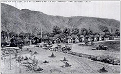
 A 1920 postcard of Gilman Hot Springs | |
| Coordinates: 33°50′09″N 116°59′20″W / 33.83583°N 116.98889°WCoordinates: 33°50′09″N 116°59′20″W / 33.83583°N 116.98889°W ⧼validator-fatal-error⧽ | |
| Country | United States |
| State | California |
| County | Riverside |
| Elevation | 1,480 ft (450 m) |
| Time zone | UTC-8 (Pacific (PST)) |
| • Summer (DST) | UTC-7 (PDT) |
| ZIP Code | 92583 |
| Area code(s) | 951 |
| GNIS feature ID | 1660675 |
Gilman Hot Springs is an unincorporated community in Riverside County, California, United States. Located on California State Route 79, it is 4 miles (6.4 km) north-northwest of San Jacinto. The community has a post office which opened in 1938 and shares the ZIP code 92583 with San Jacinto.[1]
Sidney James Branch settled Gilman Hot Springs in 1881 and built the Relief Springs Hotel there in 1888. Originally known as San Jacinto Hot Springs, the community was renamed after William and Josephine Gilman, who purchased the hotel in 1913.[2]
Gold Base, the international headquarters of the Church of Scientology, is located near Gilman Hot Springs.
References[edit]
- ↑ ZIP Code Lookup
- ↑ Durham, David L. (1998). California's Geographic Names: A Gazetteer of Historic and Modern Names of the State. Quill Driver Books. p. 1421. ISBN 1-884995-14-4. Search this book on

This article "Gilman Hot Springs, California" is from Wikipedia. The list of its authors can be seen in its historical and/or the page Edithistory:Gilman Hot Springs, California. Articles copied from Draft Namespace on Wikipedia could be seen on the Draft Namespace of Wikipedia and not main one.
- ↑ "Gilman Hot Springs Geographic Information". flatlong.com.


