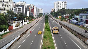
Karimanal
Script error: No such module "Draft topics".
Script error: No such module "AfC topic".
Karimanal | |
|---|---|
village | |
| Coordinates: 8°31′31″N 76°53′14″E / 8.5254°N 76.8872°ECoordinates: 8°31′31″N 76°53′14″E / 8.5254°N 76.8872°E ⧼validator-fatal-error⧽ | |
| Country | |
| State | Kerala |
| District | Thiruvananthapuram |
| Talukas | Thiruvananthapuram |
| Government | |
| • Body | Thiruvananthapuram Corporation |
| Languages | |
| • Official | Malayalam, English |
| Time zone | UTC+5:30 (IST) |
| PIN | |
| Telephone code | 0471 |
| Vehicle registration | KL-22 |


Karimanal is a locality in Thiruvananthapuram district in the state of Kerala, India. This area holds the postal code (PIN code) of 695583. This is part of Thiruvananthapuram City Corporation and comes under Attipra village office. This is near Kulathur area and is part of ward 97-Kulathur[3], Thiruvananthapuram corporation.
In the local language - Malayalam - the meaning of this place is "Black Sand" owing to the color and texture of surface soil in most of this area. From the highest points of this area, one can see a beautiful view of the Arabian sea towards the west.
This place is located between Thamburanmukku and Kuzhivila on National Highway 66 (India). This is around 6 km away from both Kazhakkuttam[4] and Chakka bypass junction near airport.
General information
- District : Thiruvananthapuram;
- Corporation : Thiruvananthapuram;
- Ward : Kulathur (#97);
- Polling Station : Government UP School (#90), Kuzhivila[5]
Transport[edit]
BUS
- City buses from Eastfort bust station running towards Venjarammoodu or Attingal via NH66 (old NH Bypass) have stops at Kuzhivila, MGM School and Thamburanmukku.
- Perumathura or Stationkadavu buses from Eastfort bus station also can be used to reach Veli Railway Station by getting down at Poundukadavu bus stop. Veli railway station is at walkable distance from Karimanal.
- From Kazhakkuttam, take any bus that goes through NH66 (towards Chakka junction) to Eastfort bus station.
TRAIN
- Veli railway station is in Poundkadavu which is walkable distance from Karimanal[6]. Only passenger trains and very few long distance trains have stop at this location.
- Kochuveli railway station is around 4Kms away from Karimanal.
AIR
- International Terminal of Trivandrum International Airport in Chakka is around 6Km from Karimanal
- Domestic Terminal of Trivandrum International Airport in Shankumugham Beach is around 12Km from Karimanal
Prominent institutions/landmarks[edit]
- Veli Railway Station, Poundkadavu
- Infosys, Technopark Phase II, NH66, Thamburanmukku
- UST (company), Technopark Phase II, NH66, Thamburanmukku
- National Institute of Speech and Hearing (NiSH), Aakkulam - Ullooor Road[7]
Schools[edit]
- MGM Central Public School, NH66, Karimanal[8]
- Government UP School, Kuzhivila
- Government LP School, Poundkadavu
- Government Higher Secondary School, Kulathur
Nearby places[edit]
- Thamburanmukku
- Aakkulam
- Kuzhivila
- Kulathur, Attipra Village
- Kazhakkuttam
- Technopark, Trivandrum
- Venpalavattam
References[edit]
- ↑ "LocatePostOffices". www.indiapost.gov.in.
- ↑ "Pin Code: KARIMANAL, THIRUVANANTHAPURAM, KERALA, India, Pincode.net.in". pincode.net.in.
- ↑ "Local Self Government Department | Local Self Government Department". lsgkerala.gov.in.
- ↑ Sep 21, Aswin J. Kumar / TNN / Updated. "Kazhakkoottam-Muttathara sewage line: Tough task ahead | Thiruvananthapuram News - Times of India". The Times of India.
- ↑ http://www.ceo.kerala.gov.in/pdf/POLLINGSTATION/AC132.pdf
- ↑ https://trainspy.com/nearestrailwaystations/KARIMANAL+Tvm+Kerala+Thiruvananthapuram
- ↑ "National Institute of Speech and Hearing, Thiruvananthapuram | District Thiruvananthapuram, Government of Kerala | India".
- ↑ "MGM Central Public School | Best CBSE School Trivandrum". mgmschool.com.
| This article related to a location in Thiruvananthapuram district, Kerala, India is a stub. You can help EverybodyWiki by expanding it. |
This article "Karimanal" is from Wikipedia. The list of its authors can be seen in its historical and/or the page Edithistory:Karimanal. Articles copied from Draft Namespace on Wikipedia could be seen on the Draft Namespace of Wikipedia and not main one.


