NAIA Road
| NAIA Road | ||||
|---|---|---|---|---|
| MIA Road | ||||
| Lua error in Module:Infobox_road/map at line 15: attempt to index field 'wikibase' (a nil value). | ||||
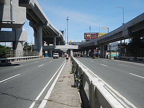
 NAIA Road eastbound towards the Domestic Road junction with the elevated NAIA Expressway | ||||
| Route information | ||||
| Maintained by the Department of Public Works and Highways | ||||
| Length | 2.5 km (1.6 mi) | |||
| Component highways | ||||
| Major junctions | ||||
| West end | ||||
| East end | ||||
| Location | ||||
| Major cities | Pasay and Parañaque | |||
| Highway system | ||||
Roads in the Philippines
| ||||
The NAIA Road (Ninoy Aquino International Airport Road), formerly known and still commonly referred to as the MIA Road (Manila International Airport Road), is a short 8-10 lane divided highway connecting Roxas Boulevard and the Manila–Cavite Expressway (R-1) with Ninoy Aquino International Airport (NAIA) in southwestern Metro Manila, Philippines. It is also a major local road that links the cities of Pasay and Parañaque running approximately 2.5 kilometers (1.6 mi) underneath the elevated NAIA Expressway from R-1 in Tambo, Parañaque to NAIA Terminal 2 in Pasay. En route, it intersects, from west to east, Quirino Avenue, Domestic Road, and Ninoy Aquino Avenue. The road ends at the entrance of NAIA Terminal 2.
The road also houses a small strip of shops across from the former Coastal Mall, Tambo Elementary School at Quirino Avenue, Park 'N Fly at Domestic Road, and the old Nayong Pilipino (site of the future NAIA Terminal 5)[2] close to Terminal 2. The old NAIA Terminal 1 is accessible by turning south at Ninoy Aquino Avenue, which also leads to the Duty Free FiestaMall and continues on to Sucat as Dr. Santos Avenue. The new Terminal 3, on the other hand, is located on Andrews Avenue which can be accessed from Domestic Road. The road was originally named as MIA Road and was only renamed in 1987 when the airport was renamed in honor of the late Senator Ninoy Aquino, who was assassinated there in 1983.
References[edit]
- ↑ "Road and Bridge Inventory". Department of Public Works and Highways. Retrieved June 1, 2023.
- ↑ Rosales, Elijah Felice (March 19, 2024). "New NAIA terminal eyed at Nayon site". The Philippine Star. Retrieved March 19, 2024.
Coordinates: 14°31′0″N 120°59′59″E / 14.51667°N 120.99972°E
| This Philippine road or road transport-related article is a stub. You can help EverybodyWiki by expanding it. |
This article "NAIA Road" is from Wikipedia. The list of its authors can be seen in its historical and/or the page Edithistory:NAIA Road. Articles copied from Draft Namespace on Wikipedia could be seen on the Draft Namespace of Wikipedia and not main one.

