Scovern Hot Springs, California
| Scovern Hot Springs | |
|---|---|
| Agua Caliente Neills Hot Springs Hot Springs House | |
 Neills Hot Springs Hotel in 1911 | |
| Location | Hot Springs Valley, Kern County, California |
| Elevation | 2,490 ft |
| Type | geothermal |
| Discharge | 140-to-149 gallons per minute |
| Temperature | 113°F /45°C |
Scovern Hot Springs | |
|---|---|
Former settlement | |
 Scovern Hot Springs Location in California | |
| Coordinates: 35°37′17″N 118°28′27″W / 35.62139°N 118.47417°WCoordinates: 35°37′17″N 118°28′27″W / 35.62139°N 118.47417°W ⧼validator-fatal-error⧽ | |
| Country | United States |
| State | California |
| County | Kern County |
| Elevation | 2,490 ft (759 m) |
Scovern Hot Springs (also known as Agua Caliente, Neills Hot Springs and Hot Springs House) is a thermal spring system, and former settlement in the Kern River Valley of the Southern Sierra Nevada, in Kern County, California.[1][2]
History[edit]
The thermal springs in the area have been used by Native Americans and later by Spanish settlers for their balneotheraputic qualities.[3]
The Hot Springs Valley (now called Lake Isabella Valley) in Kern County was inhabited by the Palagewan people who lived along the Kern River's north fork. Other indigenous groups using the area were the Foothill Yokuts, Pahkanapil, Kawaiisu and Tübatulabal people.[4][5]
A Tübatulabal village was located at the site of Scovern Hot Springs.[6] The Tübatulabal, a Uto-Aztecan-speaking people, are considered to have been the "first stewards of the region." Their complex societal structure and innovative trade network was based on seasonal patterns in relation to the land.[7] The Tübatulabal engaged in limited agriculture by harvesting local crops and herding animals in a semi-nomadic fashion. They maintained semi-permanent dwellings with rock foundations within their villages located throughout the valley.[4]
When the Spanish first arrived in the area in the late 1700s, they came in contact with the Tübatulabal and Kawaiisu in the region. During the early 1800s these indigenous people had limited trade-related transactions with the Euro-Americans. These cultural dynamics shifted when gold was discovered in 1848 at Sutter's Mill which brought thousands of miners to inland California including many to the Kern River and Lake Isabella valleys.[8]
The first white man to reach the Kern River was the Franciscan Padre Francisco Garcés on his overland journey to Monterey from the Spanish settlements in New Mexico. In May, 1776 (before the signing of the Declaration of Independence) Garcés landed at Woilo, a Yokuts village. The Yokuts helped the Padre (who could not swim) cross the body of water. Garcés named the river the Rio San Felipé, although the indigenous people called it PO-sun-co-la. Seventy years later the river was renamed the Kern River by John C. Frémont after the artist and cartographer Edward Meyer Kern, a surveyor on Frémont's exploratory trips.[9] The Tübatulabal first made contact with Garcés in 1776, and later with Frémont in 1834, and with the Walker expedition in 1843.[4]
The Scovern Hot Springs are located in the South Fork Kern River region. For a time, the springs were known as Agua Caliente, and as Neills Hot Springs.[3]
Former settlement[edit]

The California Department of Conservation states that Scovern hot springs as well as several other hot springs along the Kern River have "historically been developed for resort/spa use."[10]
The former settlement of Scovern Hot Springs was located at the site of a geothermal spring system in the central area of Hot Springs Valley. In the 1800s it was a stop for horse-drawn stage coaches on the road between the town of Old Kernville and the railroad stop at Caliente. Ruins of the settlement that burned in 1971 could be seen until the mid-1990s when the remaining structure collapsed.[11]
In 1866, the hot springs became known to local settlers when the "Hot Springs House", a hotel and bathhouse, was built on the site to accomodate miners.[2][12] Visalia W. Delta wrote in 1866 that the thermal waters were presented as curative of "peculiar inducements to invalids, especially those suffering from chronic diseases." She goes on to write that the owners at the time guaranteed the spring water was a "speedy cure of the most obdurate cases." During this time, the owners planned to develop the faciliites for "families wishing to sojourn here" to offer them accommodations to stay for weeks at a time. The cost of room and board was $15 per week, including the use of the mineral baths.[3] In 1867 the "Ranch House" building was built at Scovern Hot Springs.[13] The hot mineral spring water at the bathhouse was purported to cure various ailments. For a time the facility was operated by a subsidiary of the Kern County Hospital.[2]

In 1902 John Neill purchased the "Hot Springs House", which at that time consisted of the hotel, a restaurant and a mineral spa.[12] In 1915 the resort was completed with the addition of a swimming pool.[3] Neill's wife Annie managed the hotel and its employees. John Neill's cousin, Robert Little, took care of the bath house. The old wooden mud-bath soaking tubs were updated with galvanized soaking tubs. Chinese cooks from the town of Kernville prepared food for guests. These upgrades brought tourists to the hot springs.[12] Eventually, boarders rented rooms month-to-month, dined in the restaurant and participated in events such as weekend square dances.[12]
The Neill family also bought the surrounding 840 acres which was farmed for alfalfa. The ranch raised sheep and cattle and a slaughterhouse was opened on-site.[14][12] A local biographer wrote of the ranch and homestead that it had “ample barns and other out-buildings and [was] supplied with implements and appliances of every kind essential to diversified farming.”[15]
In 1929, Louis G. Scovern and his wife Edna[16] purchased the property, renamed it "The Scovern House", and a swimming pool and additional bath houses were constructed.[2]
In 1938, the hot springs resort spa was described as a popular watering place.[17] For a time a dude ranch was operated at Scovern Hot Springs.[18] In the late 1930s, Mr. and Mrs. H.A. Page managed the Scovern's Hot Springs Ranch.[13] In the 1930s and 40s the Sierra Roundup Rodeo took place at Scovern Hot Springs.[19][20] The Scovern's daughter Pauline and her husband Johnny E. McNally, a ranch hand at the hot springs resort were married in 1936; McNally went on the produce the annual Sierra Rodeo Round-up held at Scovern Hot Springs.[21] In 1941 Scovern Hot Springs was called a "leading settlement Kern's 19th century mining days" by the Bakersfield Californian newspaper.[22]
The Scovern Hot Springs House burned to the ground in 1971. All of the resort buildings are gone, leaving only the natural hot spring. Visitors to the areas can observe the steam rising throughout the wetland fields across from the spring system.[2]
Hot springs water profile[edit]
The hot water emerges from several spring sources in the Quaternary and Tertiary sedimentary rocks and alluvial material within the Kern Canyon geological fault zone.[3][23]
The average temperature is 113° F / 45° C, flowing from the source at a rate of 140–to–149 gallons per minute.[24] Spring no. 1 emerges from the ground at 132° F / 56° C, at a rate of flow of 330 liters per minute (87 gallons per minute).[25] Two additional unnamed thermal wells are located near the primary Scovern hot springs.[26] Unnamed well no. 1 is 116° F / 47° C, and unnamed well no. 2 is 127° F / 53° C.[27] In addition to balneologic uses, the spring water was used for irrigation.[28]
Location[edit]
Scovern Hot Springs is located in the South Fork Kern River region 2.25 miles (3.6 km) north-northeast of Bodfish,[29] at an elevation of 2490 feet (759 m).[1] Scovern Hot Springs still appeared on maps as of 1943.[1]
The springs are located in the Kern Canyon fault zone[28] within the 225-acre Hot Springs Valley Wetlands complex. Due to the high-discharge rate of the springs, the water flows throughout the wetlands area at the daily average rate of 300,000 gallons.[30]
Gallery[edit]
-
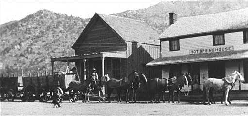
Horse-drawn mining carriages at Hot Springs House in 1900
-

Tübatulabal family in 1916, photo: Thomas T. Waterman, U.C. Berkeley
-
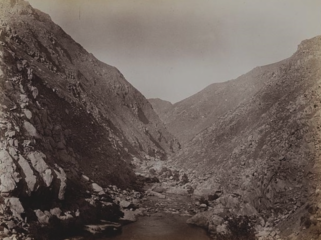
Kern River Canyon in 1888


See also[edit]
References[edit]
- ↑ 1.0 1.1 1.2 1.3 U.S. Geological Survey Geographic Names Information System: Scovern Hot Springs, California
- ↑ 2.0 2.1 2.2 2.3 2.4 "Hot Springs Guide, Sequoia National Forest". Kern Valley Canyon Connection. Kern Valley, U.S. Forest Service, Department of Agriculture. Retrieved 26 January 2021.
- ↑ 3.0 3.1 3.2 3.3 3.4 Wilkerson, Gregg. "Geology and Mining of the Kern County, Lake Isabella and Walker Basin, Kern County California". American Association of Petroleum Geologists, Pacific Section. pp. 66–67. Retrieved 27 January 2021.
- ↑ 4.0 4.1 4.2 "Cutural Resources of the Kern River Valley". Audobon California Kern River Preserve. Audubon. Retrieved 26 January 2021.
- ↑ Vogelin, Erminie W. (1938). "Tübatulabal Ethnography" (PDF). Antropological Records, University of California Press. 2 (1). Retrieved 26 January 2021.
- ↑ Park, Willard Z.; Siskin, Edgar E.; Cooke, Anne M.; Mulloy, William T.; Opler, Marvin K.; Kelly, Isabel T. (1938). "Tribal Distribution in the Great Basin, Part 1". American Anthropologist. 40 (4): 635. doi:10.1525/aa.1938.40.4.02a00060. JSTOR 661617. Retrieved 27 January 2021.
- ↑ ACoE, 2020 p. 62.
- ↑ ACoE, 2020 p. 13–15.
- ↑ Wilkerson, 2017, p. 16.
- ↑ Youngs, Leslie G. (1994). California Low-temperature Geothermal Resources Update. Sacramento: State of California Department of Conservation, Division of Mines and Geology. p. 13. Search this book on

- ↑ Connelly, Russ. "Historical Tour of State Highway 178: From the Kern Canyon to Freeman Junction". Kern Canyon. Retrieved 26 January 2021.
- ↑ 12.0 12.1 12.2 12.3 12.4 Lemke, Susannah; Kraus, Geneva (2020). Isabella Lake Cultural Resources (PDF). Sacramento: U.S. Army Corps of Engineers. pp. 23–25. Retrieved 26 January 2021. Search this book on
- ↑ 13.0 13.1 "Glendale Man Finds Prehistoric Caves". San Pedro News Pilot. 2 December 1937. Retrieved 26 January 2021.
- ↑ Powers, Bob (1989). Hot Springs Country. Glendale: Arthur H. Clark Company. p. 31. ISBN 978-0870621949. Search this book on
- ↑ Morgan, Wallace M. (1914). History of Kern County, California with Biographical Sketches. Los Angeles: Historic Record Company. Search this book on
- ↑ Sherer, John Calvin (1923). History of Glendale and Vicinity. Glendale, California: Glendale History Publishing Company. p. 430. Retrieved 27 January 2021. Search this book on
- ↑ "Spas Abound in Southland". The Los Angeles Times. 23 December 1938. Retrieved 26 January 2021.
- ↑ "Kern Offers Tourists Wide Scenic Range: County Resorts are Preparing to Welcome Vacation Throngs". The Bakersfield Californian. 16 March 1940. Retrieved 26 January 2021.
- ↑ "Sierra Rodeo Draws Record Crowd at Scovern Hot Springs Ranch". The Bakersfield Californian. 4 September 1946. Retrieved 26 January 2021.
- ↑ "Annual Sierra Round Up Is Successful, Winners Listed". The Bakersfield Californian. Retrieved 26 January 2021.
- ↑ "McNally's Fairview Lodge and Restaurant". Sierra Nevada Tourism. Retrieved 27 January 2021.
- ↑ "Limitless Kern Caves may be Tourist Lure: Colossal Caverns Wind for Miles Under City". The Bakersfield Californian. 27 September 1941. Retrieved 26 January 2021.
- ↑ Willkerson, Gregg. "Kern Canyon, Lake Isabella and Walker Basin, Kern County, California: Geology and Mining History: Area Maps (See pdf pages 6 and 7 of geologic road maps)". University of California. Retrieved 27 January 2021.
- ↑ Berry, George W.; Grim, Paul J.; Ikelman, Joy A. (1980). Thermal Spring List for the United States. Boulder, Colorardo: National Oceanic and Atmospheric Administration. p. 12. Retrieved 26 January 2021. Search this book on
- ↑ "California Geology". 92. California Division of Mines and Geology (original: University of California). 1983: 135. Retrieved 26 January 2021.
- ↑ Bliss, James D. (1983). California, Basic Data for Thermal Springs and Wells as Recorded in GEOTHERM: Part A. Menlo Park, California: United States Geological Survey. p. 42, 77. Retrieved 27 January 2021. Search this book on
- ↑ USGS 1983, p.14
- ↑ 28.0 28.1 Stearns, Norah D.; Stearns, Harold Thornton; Waring, Gerald Ashley (1937). Thermal Springs in the United States. USGS, U.S. Government Printing Office. p. 128. Retrieved 27 January 2021. Search this book on
- ↑ Durham, David L. (1998). California's Geographic Names: A Gazetteer of Historic and Modern Names of the State. Clovis, Calif.: Word Dancer Press. p. 1103. ISBN 1-884995-14-4. Search this book on
- ↑ "Hot Springs Valley Wetlands". Kern River Valley Heritage Foundation. KRVHF. Retrieved 26 January 2021.

This article "Scovern Hot Springs, California" is from Wikipedia. The list of its authors can be seen in its historical and/or the page Edithistory:Scovern Hot Springs, California. Articles copied from Draft Namespace on Wikipedia could be seen on the Draft Namespace of Wikipedia and not main one.